AAA Magazines

Four amazing scenic drives in Southern California

Live Oak Canyon Road Live Oak Canyon Road. | Photo by Tiffany Luong

These classic SoCal routes are short in length but long on leisure.

I have a confession to make. Something I never thought I’d say when I was young. Here it is: Driving can be boring.

When I first got my license, the freedom of driving was exhilarating. I couldn’t wait to roam where I wanted in my parents’ station wagon. The beach. The mountains. The desert. Every trip was an adventure.

Life continued. I graduated from college and got a job, a wife, and a family. I started making the same daily commute down the same crowded freeway, seeing the same faces trapped behind their windshields. I got in a driving rut.

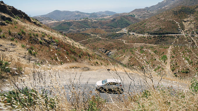
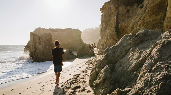
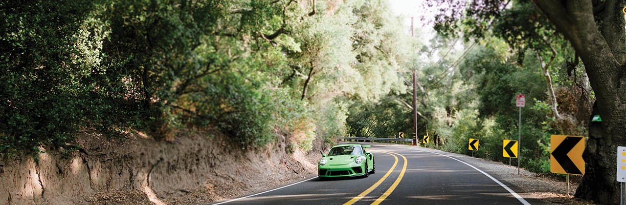
Eventually, I found a way out. I began to seek special weekend routes, the kind my parents called Sunday drives—mini excursions that have three components: an interesting road or roads, attractive scenery, and a place to picnic. For me, these drives include the twisty route up to a friend’s cabin in Big Bear and the easy cruise down Pacific Coast Highway past the beach towns of Carlsbad and Encinitas.

After months of being cooped up, perhaps you, like me, are ready to head out again—but are wary of embarking on a long road trip that requires overnight stays and extensive planning. Sunday drives are the perfect in-between solution. Following are four fun stretches of pavement to get you started. Each can be enjoyed without ever stepping out of your car, or as a leisurely day trip with pleasant stops along the way. What are you waiting for?—Paul Zieke

Scenic Drive 1. Orange County: Canyons and Parks

Length: About 27 miles one way.

The route: Beginning at Irvine Regional Park in Orange, head south on East Santiago Canyon Road to Live Oak Canyon Road and follow the signs to O’Neill Regional Park. From O’Neill, backtrack 3 miles on Live Oak Canyon, then turn left onto El Toro Road, right on Glenn Ranch Road, and right on Portola Parkway. The Borrego entrance to Whiting Ranch Wilderness Park is on the north side of the Foothill Ranch Marketplace.

The kiddie railroad at Irvine Regional Park.

The kiddie railroad at Irvine Regional Park. | Photo by Tiffany Luong

Orange County’s canyons convey an aura of mystery and legend, with names that spill out as if from a B-movie Western: Santiago, Black Star, Silverado, Limestone, Trabuco, and Red Rock. In reality, this canyon-country route, long tamed for the automobile and also favored by bikers and cyclists, is an ideal outing for nature lovers and active families. Combine this drive with visits to two regional parks and one of Orange County’s most popular wilderness hikes. —Brad Wright

Along the way: Irvine Regional Park, California’s oldest regional park, was founded by James Irvine Jr. to protect the regal stands of coast live oaks at what in the late 1800s was known simply as the “Picnic Grounds.” Today, the park remains an idyllic place, even more so if you have youngsters in tow. There’s a small zoo, a kiddie railroad, pony rides, shoreline fishing, and surrey bicycle and big-wheel paddleboat rentals. Parking: $3, weekdays; $5, weekends.

Sweets on sale at Silverado Canyon Market.

Sweets on sale at Silverado Canyon Market. | Photo by Tiffany Luong

From East Santiago Canyon Road, take a short but scenic detour on Silverado Canyon Road to the Silverado Canyon Market for premade sandwiches, fresh-baked cookies, or other last-minute picnic supplies.

Red Rock Canyon at Whiting Ranch Regional Park.

Red Rock Canyon at Whiting Ranch Regional Park. | Photo by Eric Van Eyke

The easy 2-mile (one-way) hike to Red Rock Canyon in Whiting Ranch Wilderness Park is a fitting end to this park-to-park-to-park jaunt. The geologic wonder, reminiscent of the badlands of northern Arizona, is most magical as the sun begins to drop. But leave time to return to your car before dark. Parking, $3.

Picnic place: At O’Neill Regional Park, grab a picnic table in the Mesa Day Use area on a ridge overlooking the Santa Ana Mountains. After lunch, stroll the StoryWalk to follow the adventures in the latest laminated children’s book. Books change monthly. Parking: $3, weekdays; $5, weekends.

Scenic Drive 2. Santa Barbara County: Mission to Mission

Length: About 56 miles one way.  

The route: Beginning at Old Mission Santa Barbara, head north on Mission Canyon Road, taking Foothill Road/State Route 192 west to State Route 154 up and over San Marcos Pass. Continue past Lake Cachuma to Los Olivos, turning left at Grand Avenue. Bear right at Alamo Pintado Road, and follow that to Mission Drive/State Route 246. Head west past Mission Santa Inés, through Solvang and all the way to Lompoc, veering right at Purísima Road toward La Purísima Mission. Head back to Santa Barbara on the coastal route via Highway 1 to US Highway 101 south.

Ostrichland USA

Some of the residents at Ostrichland USA. | Photo by Tiffany Luong

The Franciscans carefully spaced the California missions so travelers could walk from a mission to the next closest one in three days. Centuries later, you can drive to three of them in a single afternoon on the peaceful country roads of Santa Barbara County—and still find time to greet amazing animals, stroll nostalgic villages, and sip pinot to the strains of classic rock. —Starshine Roshell

Along the way: Los Olivos is a one-horse Western town dotted with prairie-style Victorian buildings, art galleries, wine-tasting rooms, and antiques shops. Download the walking tour from losolivosca.com before you go, and grab fresh, hearty, inventive picnic fare at Panino

Pull over at Quicksilver Ranch for a gander at the miniature horses roaming there—some no bigger than a Great Dane. Then stop at Ostrichland USA to feed the fluffy ostriches and emus, or just catch a glimpse of the marvelous creatures as you drive past. Admission: $2–$5; $1 per feed bowl.

La Purisma Mission

La Purisma Mission. | Photo by Tiffany Luong

La Purísima Mission is the state’s most extensively restored mission. Wander its nature trails, peek into its blacksmith shop, snap a photo at the romantic fountain, and befriend snorting penned beasts, from giant pigs to a magnificent long-horned bull. Parking, $6. 

Babcock Winery in Lompoc

Babcock Winery. | Photo by Tiffany Luong

Picnic place: Bring your own lunch to the picnic tables at Babcock Winery in Lompoc or order from its menu, provided by the scrumptious Industrial Eats. Enjoy a glass of Ocean’s Ghost Pinot Noir and check out the sprawling boutique of vintage rock ’n’ roll memorabilia and other midcentury-modern treasures in the winery’s Soulstruck Lounge.

Scenic Drive 3. Riverside and San Diego Counties: Desert Dreamscape

Length: About 66 miles one way  

The route: Head south out of Temecula on State Route 79. After 37 miles, turn left onto San Felipe Road, then left again on Montezuma Valley Road. The twisty drive down the steep grade into Borrego Springs ends at Palm Canyon Drive, where a left turn takes you to the Anza-Borrego Desert State Park Visitors Center. Turning right on Palm Canyon takes you to Christmas Circle at the center of town.

Borrego Springs is surrounded by Anza-Borrego Desert State Park, the largest state park in California. The drive there from Temecula is a good way to enjoy spectacular desert scenery without straying too far from civilization. —Paul Zieke

Ricardo Breceda's serpent sculpture crosses Borrego Springs Road. | Photo by Tiffany Luong

Ricardo Breceda's serpent sculpture crosses Borrego Springs Road. | Photo by Tiffany Luong

Take in Borrego Springs’ most unusual attraction—the more than 100 fanciful metal sculptures by artist Ricardo Breceda (many of them visible from Borrego Springs Road), from wild horses to fighting dinosaurs to a 350-foot serpent. Free tour maps are available at the Chamber of Commerce near Christmas Circle Park. More works are on view at his headquarters in Aguanga, about 19 miles east of Temecula.

The Slot, a canyon in Anza-Borrego State Park

The Slot. | Photo by Leslie Mieko Yap

The Anza-Borrego Desert State Park Visitors Center is a good place to find out about road conditions, the area’s history, desert plants and animals, and hikes, including The Slot, a 0.8-mile trek through a narrow siltstone canyon. If you have four-wheel drive, the views from Font’s Point just east of town are breathtaking.

Scenic drive 4. Malibu: Mountains and Sea

Length: About 65 miles.

The route: From US Highway 101 in Calabasas, exit Las Virgenes Road (it turns into Malibu Canyon Road) toward the coast. Take PCH north to Yerba Buena Road (it turns into Little Sycamore Canyon Road). Turn left on Mulholland Highway, then left on Kanan Road to return to the 101.

Yerba Buena Road

Yerba Buena Road. | Photo by Tiffany Luong

The famed “21 miles of scenic beauty” along Pacific Coast Highway (PCH) only scratches Malibu’s surface. To fully appreciate the beauty of this celebrity cradle, you’ll also want to scale the heights of the Santa Monica Mountains. This best-of-both-worlds Malibu loop takes in some of the planet’s most desirable coastal real estate and some of greater L.A.’s most rugged mountain terrain. —Brad Wright

Along the way: Get your bearings to the Santa Monica Mountains National Recreation Area at the visitors center on the grounds of the King Gillette Ranch, a short detour off Las Virgenes Road. Take the half-mile trek to Inspiration Point for 360-degree views of the razor magnate’s historic Spanish Colonial Revival–style mansion, the broad meadows of the Las Virgenes Valley, and the rock formations of Malibu Creek State Park. Free two-hour parking.

El Matador Beach

El Matador Beach. | Photo by Tiffany Luong

If the small parking lot at El Matador Beach is full, look for a spot along either side of PCH. An overlook on the bluffs offers a spectacular view of sea stacks and rock arches, and a steep staircase leads to the sand, where at low tide you can explore the sea caves. Lot parking, $8; street parking, free.

The ranger station at Circle X Ranch, a former Boy Scouts camp near the popular Sandstone Peak trailhead, is a good spot to stretch your legs and take a break from the white-knuckle mountain driving.

Picnic place: Malibu Bluffs Park, across PCH from Pepperdine University, has free parking and picnic tables overlooking the ocean.

AAA Travel Alert: Many travel destinations have implemented COVID-19–related restrictions. Before making travel plans, check to see if hotels, attractions, cruise lines, tour operators, restaurants, and local authorities have issued health and safety-related restrictions or entry requirements. The local tourism board is a good resource for updated information.

Travel offers and deals

Mom on kids on roller coaster

Entertainment savings

Save big with AAA discounts on tickets to your next adventure.

Learn more

Woman at airport looking at arrival and departure screen

Travel with confidence

Purchase travel insurance with Allianz Global Assistance.

Learn more

Infinity pool

Hot travel deals

Get the latest offers from AAA Travel’s preferred partners.

Learn more

Makena Beach, Maui, Hawaii

Travel with AAA

See how we can help you plan, book, and save on your next vacation.

Learn more

back to top icon